PART 1 - ROADTRIP
To start out, it was Juli's birthday on the 17th of July, and for her big day she wanted a road trip. I made a detour through Joseph, John Day, and Bend on my way back to Grants Pass from Sandpoint awhile back, and I told her how beautiful the drive was, so she decided that's where she wanted to go. I negotiated a few days off to make the trip, and thankfully my supervisor generously cooperated. I have to admit though that I was a bit selfish in making these plans. Two sites that I'd always wanted to fly just happened to lie along the route, one being Pine Mtn. near Bend and the other being Mt. Howard in Joseph.
Bend was the site from which the Oregon State cross-country record had been set (163 miles by Mike Tingy) , so I had high expectations. Unfortunately, high expectations often lead to high disappointments. The day before, Patrick Kruse, the local site orienteer reported that pilots had been getting up to 15,000-plus - a great start for a long XC flight. When I met up with Patrick, Scott, Joe our driver, and Chuck, however, the wind was switchy with a dominant north direction. The launch faces west, so that meant we'd have to wait for a reasonable cycle (at least 45 degrees from straight up the face) to launch.
Meanwhile, on the way up the mountain we came to a van that had driven partially off the narrow, steep road and was blocking the way to launch. A pickup belonging to paraglider pilots was parked about 100 yards below, and we'd heard that they'd hiked on up to launch, telling the occupants of the van that some hang gliders were on their way and would help out since we couldn't pass otherwise. So much for comraderie. We did help out and got the van back on the road, but in the process, another van belonging to a separate group of paragliders backed into the passenger door of my pickup. The driver was very upset & apologetic and gave me her number so we could coordinate repairs.
The flight wasn't anything to write home about. We each picked the best cycle we could find, and although the first two pilots managed to gain over 1,000', I launched into the downcycle and we all headed down to the bailout together. I landed first, flaring over the knee-high sagebrush for a no-stepper, and Scott followed with a not-so-pretty no-winder that resulted in a hard landing, destroying his control frame. Patrick followed next with a fast, hard flaring finish and both feet on the ground. Chuck launched after all of us and climbed to 12,000-plus for a nice out-and-back on his rigid wing. Timing is everything in this sport, and ours was just a bit off...
From Pine, we headed across the badlands of Oregon to the painted hills and Mitchell, where we booked a room in a historic hotel in this 'Twilight Zone' of a town. I won't go into the details of our 'adventure' here, except to say avoid room #10. In fact, avoid the hotel entirely - it's managed by a woman who would obviously rather be elsewhere if her dad wasn't running the gas station across the street and she didn't have two loud, obnoxious children tying her down to this spot. Henry the bear, who is caged at the gas station, also appeared to want to be elsewhere. So did we, and we left early the next day, stopping in John Day to tour a chinese heritage center (well worth the visit).
The highlight of the trip was Joseph, a beautiful little artist's community at the base of the Eagle Cap Wilderness. Joseph was named for Chief Joseph, the Nez Pierce leader who evaded the U.S. Cavalry led by General Howard in the mid-1800's. Howard was sent to round up Joseph's people and deliver them to a reservation in Idaho, but Joseph (originally named Thunder-Rolling-Down-The-Mountain) was a skilled tactician and eluded the cavalry for many miles, finally surrendering with his band of remaining warriors, elderly and children just a few miles from the Canadian border and freedom.
Joseph is a beautiful little town skirted to the south by the Wallowa Mountains, including Mount Howard. The top of Howard is accessed by tram, and here among the peaks towering 4,000' above the valley floor is where I hoped to fly from. This site and Glacier Point in Yosemite are the two main reasons I'd attained my advanced hang glider rating, which is required to fly both sites. Dr. Philip Stonebrook, the official site orienteer, was an old friend of mine. He and his wife, Jodie, had moved here from the Rogue Valley, and I had flown with Philip several times when I first got into this sport. Our plan was to pitch a tent in a nearby campground and visit the Stonebrooks, but Philip insisted that we stay at their place, enjoying the generosity of their comfortable accomodations, amazing meals and fine company. A good friend of theirs, Bob, was visiting from Ashland and insisted on buying us all dinner (Juli's birthday dinner) at the local pub. We gratefully accepted.
 The next day Philip and I scouted out the bailout lz to Mount Howard as well as the alternate (and preferred) lz near his house several miles from the mountain. Then Philip, Jodie, Juli and I loaded my gear and headed for the park at the far side of Wallowa Lake where the tram departed for the top of the mountain. Some years ago Philip had created a system for attaching gliders to gondola cars to transport to the top, and it worked great. After a scenic trip up the tram we were at the top of Mt. Howard. We packed my wing and harness the 1/4 mile or so down the trail and I began my setup procedure as a small crowd gathered near launch. After assembly was complete, I climbed into my harness, carried the glider to launch, and awaited a good cycle while taking in the view of the lake and valley below and mountains to either side.
 When a straight sustained cycle rolled up the face I launched to the cheers of the croud and headed out to where Philip told me I'd find the resident thermal. Sure enough it was where he said, and I began climbing slowly to about 9,500'. It was a weak core and eventually I topped it out, so I headed back out front to try to find another one. I'd dropped well below launch before heading back to where I'd first found lift. Fortunately, a hawk was working some lift in front of the hill, so I joined him, this time to find a strong core that took me to around 11,500'. At this point I was high enough that I could see deep into the wilderness behind launch and the mountain peaks that seemed to go on forever to the south. Deep blue mountain lakes were now visible, as were snow covered cirques and craggy peaks. What an incredible view!
 After topping out, I radioed down that I was heading across the lake and over to Chief Joseph Mtn., a long steep ridge that continued several miles to the west. My hope was to work my way to the top of the ridge where more thermals would be found, but the best I could do was work to within a few hundred feet of the top. I managed to glide the entire length of the ridge, however, and well beyond the lz near Philip's house, so after working the foothills below the face while the clouds shut off the lift, I headed to the big field out front, dropped my wind flag, and set up for a nice smooth landing. Juli and Philip soon showed up to help load the gear, and we returned to enjoy more of Philip and Jodie's hospitality. The flight lasted about an hour and forty-five minutes, and I was in awe of the amazing scenery for most of it. I will definitely be back for more!
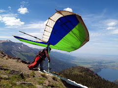
No comments:
Post a Comment