The first couple of flights weren’t very exciting for me. I was hoping to leave Sugar Hill and at least make it to Lakeview, but the lift there is squirrelly and the best I could get was about 8,000 ft. ASL – not enough for a comfortable cross-country flight. There were some personal-best flights logged from a friend, however. The first one resulted in a climb to 16.8k and a land-out halfway between Fort Bidwell and Adel which by my estimation would be about a 20-mile flight. The second took him from Sugar to 13 miles north of Lakeview – around 35 miles overall. There were many similarly long and high flights by others as well.
 My third flight on July 4th wasn’t a record-breaker for me, but it did take me to a place I’d always wanted to fly. Abert Rim, rising 2,500 ft. off the valley floor and extending for 30 miles into the Oregon desert, is the largest fault escarpment in North America. Abutting the north base of the rim is 15-mile-long Abert Lake which is separated from the rim by the narrow ribbon of land just wide enough for Highway 395 to wind its way toward Burns, Oregon. The shear vertical face of the rim dominates the landscape as one drives north of Lakeview, and its magnificence transcends description. I’d heard stories about its spectacular beauty from hang glider pilots who had been blessed with the opportunity to soar its heights, and I’d hoped that one day I too would share the experience. The opportunity appropriately presented itself on Independence Day.
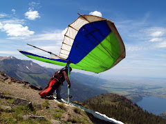
Ken and I went to the top of Black Cap, the launch overlooking Lakeview, with the intention of competing in the spot-landing contest scheduled for that day. With a couple of exceptions, it appeared that the conditions were marginally soarable, so the best we’d hoped for was a sled ride to the landing target and maybe another try later on. One of the exceptions was a semi-local pilot named Jimmy who would launch in his customary way, skimming the ground just high enough to produce gasps from the spectators and flying to the next ridge to find a decently consistent thermal. From there he would climb up to about 8,500’, fly back over launch, and strafe the crowd for a few more gasps before returning to the thermal and repeating the process. We’d both agreed that after launching we would follow his example and head directly across to the point where his thermal originated, which we’d begun referring to as Jimmy’s Boomer, with the hope of extending our flights and maybe getting a bit more airtime in before going for the spot. Anticipating a short flight, I’d decided to leave my drop flag behind and stow my gloves in my harness. As I did so, I commented to Ken that this was a sure way to guarantee a long and high flight. Duration and altitude always seem to be inversely proportional to expectation and preparation.
Ken launched first in a nice cycle, and after clearing the hill he’d started working a thermal out front for a gain of a couple hundred feet. Sticking to our intended plan, he headed across to Jimmy’s Boomer and began hunting for the core. A few minutes later, I launched in a light cycle which resulted in a launch not dissimilar to Jimmy’s – a bit too close to the shallow slope for my comfort – and headed across in mostly sinky air. I did get a slight boost on the way to the boomer, but decided not to stay and work it. As I reached the adjacent hillside and began hunting around, Ken radioed that he couldn’t find the lift and was getting low. Meanwhile, I’d found some workable lift and began circling. As I allowed the glider to drift downwind with each circuit I felt the core gain in strength until it turned into a nice solid climber – I’d found Jimmy’s Boomer.
 I continued to work the thermal for several circuits, occasionally adjusting my course to stay with the core. Instead of topping out at 8,500’, however, this time it kept rising almost to 13,000’ before beginning to dissipate. On the way up I radioed my progressive altitude to Ken who had since landed in the bailout field, and Marti & Juli who were driving our retrieval truck. With this much altitude, a cross-country flight was a must, and the only question was which way to go. I looked toward Adel twenty-odd miles to the east and Abert Rim whose unmistakable features dominated the skyline about 17 miles to the north. I’d made the flight toward Adel at the nationals last year but had never ventured any farther north than Highway 140, so the choice was clear – the rim was my goal. I leveled off, pulled my VG tight with my frozen ungloved hand, turned for the mountains deep behind Lakeview, and radioed to Marti that I was headed for Abert Rim. "I don't know where that is", she responded. "Just head north", I replied. This was to be our final conversation until after I landed.
The first eight miles along my course was heavily forested with no landing zones within normal glide, but fortunately I was flying in air relatively free of sink and reached the hills at around 8,000’ AGL. Reading the terrain, I located a second thermal 10 miles out and worked it back up another thousand feet or so. From here I could work the ridges and maintain altitude fairly easily until I reached the south end of the rim. There was only one point where I began to sweat – a relatively sinky stretch that extended a mile or so toward the valley that had me questioning my ability to glide upwind to a safe landing field, but I soon found more lift and milked it sufficiently to reach the rim. I flew about 500’ over Tagues Butte, the customary launch for soaring the rim, and from there had no trouble reaching the 30-mile-long escarpment.
Once I was alongside the sheer rock face of the rim, I relaxed and began enjoying the beauty of the valley to my left and the features of the yellow lichen-encrusted sculptural rock to my right. As I reached each spur of scree at the base of the wall, I would gain a boost of lift sufficient to allow a glimpse of the vast flat plain that extended as far as the eye could see behind the rock ledge. The beauty of the landscape sincerely defies description, and in hindsight I really wish I’d had a camera in my harness, although photos would not have even begun to do justice to the experience. It was like ascending from one world to another reminiscent of Philip José Farmer’s World of Tiers, and I was Kickaha.
About two miles past Tagues I found a spot of lift emanating from a chasm in the rock face that seemed worth working, so I began to circling lazily in a steady climb until I emerged above the cliff edge and ascended above the upper plain of the escarpment. The lift coalesced into a strong core, and as I continued to circle I noted a huge shadow on the plain below and downwind of me. I was now working my way to the base of a well-formed cumulus cloud while looking down upon the two worlds. While circling, I caught a brief radio transmission that sounded like someone saying ‘Hog, are you there?’ (I’ve been branded with the name Airhog, and Ken often addresses me as such, even though he has since bettered me in the time-aloft department). I tried responding, but couldn’t tell if my transmission was received. At the off-hand chance that I could be heard I began blathering excitedly at the view I was being blessed with. Ultimately I was never heard, although expressing my observations verbally somehow seemed to heighten the experience.
 I continued my circuits and came to the realization that once I reached cloud base I had another decision to make. Should I continue north up the rim beyond where the lake began, or should I leave the rim and head west into the valley and toward the town of Paisley? The rim would probably generate continual lift, but the lake was fifteen miles long and practically abutted the base of the escarpment leaving little or no area to land. I’d never driven the highway between the lake and the rim and had no idea what landing opportunities were there, but it looked pretty tight from my vantage point at cloud base. I’d really hate to spoil such a beautiful flight with a water landing, or be forced to land on the highway and risk becoming a hood ornament for a semi. The deciding factor was a short cloud street (more like a cul-de-sac) that extended a brief distance to the west. I once again tightened the VG and went on glide over the valley.
From 10,000’, the sage brush looks mighty small and it’s really hard to tell how big those green clumps really are, but experience has taught me that if you can see individual clumps from the air, it’s probably not a good place to land. The only alternative was a stretch of alkali flats sparsely dotted with clumps of brush. Some areas appeared to glisten with moisture, but others had discernable tire tracks. This would be my targeted landing zone. I reached the end of the cloud street and began my descent. As I was on final approach I heard a strong transmission from a distant paraglider pilot, so I responded and requested a relay to Marti. He tried twice but received no response. I thanked him for trying, identified myself and described my location in case my retrieval plans fell through. While on final, I noted the pattern of wind lines on the nearby bodies of water, so at least I had an idea of the wind direction. Just in case I was wrong, I fished my drogue chute from my harness to ensure that I had an adequately high descent rate to prevent overshooting the target. All went smoothly and I gently descended onto a clearing in the dry mud flat, flaring into a light headwind.
After unhooking, crawling out of my harness and shutting down my instruments I called Juli, Marti, and Ken’s cell phones to relay my approximate location. Reception was spotty, so all I could do was leave messages. Before beginning to break down my glider I took a look around at my surroundings, and it dawned on me just how vast this part of Oregon really is. The hard white fractured mud beneath my feet spread in all directions, yielding frequently to large clumps of sagebrush. Occasionally a jackrabbit would dart from the shade of one clump to the cover of the next. Off in the distance was the endless saffron face of Abert Rim, and in all other directions the horizon was punctuated by multicolored scarps of various sizes, the low sun angle casting mauve shadows across their crevassed faces. I’ve always felt more at home in greener, more mountainous terrain, but I couldn’t deny how beautiful this alien countryside was that now surrounded me. Beautiful but lonely. It occurred to me that I could quite possibly have landed somewhere truly remote and have to spend the night out here with just the water in my camelback and my harness to sleep in. I didn’t bring matches or provisions of any kind, and I was lucky that my landing went well and I wasn’t injured. The road was only a quarter mile or so to my south, as the occasional passing car reminded me, but that would have been a long crawl had I broken a leg.
At the peak of my survivalist fantasy, the piercing ring of my cell phone brought my thoughts back to civilization. I’ve always disliked cell phones (the banner of mine reads ‘damn phone’), but at this instant it sounded heavenly! Better yet was the voice coming through the speaker. It was Juli, my sweetie, coming to rescue me from the lonely heat of the desert! So good to hear her laughing voice, even though the weak reception cut her off mid-sentence. I finished packing my gear and hiked to the highway a few hundred yards away to find the pickup alongside the road a short distance away. Perfect timing! What a team! We loaded my harness & glider and headed back to Lakeview to catch the end of the barbecue.
The flight was only an hour and a half in duration and several miles short of my best cross-country so far, but it was one of the most unforgettably beautiful flights I’ve ever had in the six short years I’ve been flying. The only downside is that I missed the spot-landing target – by twenty-six miles!