Tuesday, August 26, 2008

Hat Creek

For the past couple of years, Ken Hawes and I and our sweeties have made it an annual event to drive down to Burney, California to partake in the yearly Hat Creek Rim Fly-in held over Labor Day weekend. This year will be no exception.


I can't recall exactly how or when I first crossed paths with the friendly folks who put on and participate in this event, but since that time we've made it a point to stay in touch. As a result, we've done our best to attend the others' events and support our respective home sites.

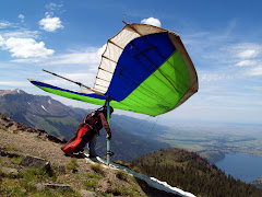
Hat Creek Rim is one of those magic places noted for its beauty as viewed from both the air and the ground. It's situated just down the road from the town of Burney, CA between the (currently) extinct volcanoes Mt. Shasta and Mt. Lassen. While the rim is noted for its amazing glass-0ff conditions, many cross-country flights into the northern California desert have started here. There's also a great campground nearby that fills with both pilots and fishermen, particularly over Labor Day weekend.

What really makes flying here fun though is the people. When Ken & I first attended the Labor Day fly-in, we were immediately greeted with open arms as 'the winged brethren to the north'. These folks love to fly and celebrate life, and they really know how to put on a fly-in. Nowhere else have I landed to the sound of such loud applause! It's enough to make your helmet too tight! There is also a talented Bluegrass band that performs each night of the weekend at the campground. Eventually, the crew ends up sitting around the campfire swapping stories (about hang gliding, of course), bad jokes, and other silly conversation. Of course, eventually someone starts making little paper helicopters to be launched over the flames, and there's an informal contest to see who can fly theirs highest and farthest.

The ladies seem to really enjoy this little get-together too. They put up with a lot from us the rest of the year, chasing us around the countryside to collect us and our gear after landing out, but they really seem to enjoy this event, no doubt because of the people. The flying here is incredible, but a nice flight is just the icing on the cake for us pilots.

Sunday, August 24, 2008

Home Again

I'm all safe and sound back in Grants Pass now. It's been a long and eventful week, and although I had a great time and learned a lot, I have to say it's good to be home.

Like at last year's Hang On, the pilots, drivers, volunteers, and hosts were about as friendly a bunch as a person could hope to meet. And of course, Mike & Gail outdid themselves once again in the organization and hospitality department.

Also similar to last year, the final task was kept local so that all the pilots and drivers could make it back in time for the awards ceremony, dinner, and of course the final blowout party. With launch from Sugar once again, the first turnpoint was north of Lakeview at Tague's Butte, the second was upwind at Black Cap overlooking the town of Lakeview, and goal was meet headquarters at Hunter's Hot Spring. The forecast called for light winds and a decent lapse rate. When we arrived, light cycles were rolling up the face of launch. Several pilots launched and struggled to climb out in the light and elusive lift, and several pilots sunk out in the bailout to the west. I decided to wait it out until conditions improved. It looked like getting away from the mountain would take a lot of patience, persistence, and stamina from the way people were struggling.

I launched next-to-last, and it was well worth the wait. I made one pass in front of the face and quickly hooked into a strong thermal that took me to 10,500 ft. before weakening at an inversion level. I was surprised that no one joined me in the climb and kept working the light lift out on the far west end. I headed out across the Fandango Valley in zero sink and, about 3/4 of the way across, I found some light lift which I patiently worked up to 13,000 ft. before finishing my crossing. From there, I could easily reach the deepest part of the ridge with plenty of altitude to spare. Dave, who had launched just before me, joined me on the ridge and together we cruised along spotting thermals for each other. We passed several gliders along the way, occasionally stopping to work lift with them before continuing on. It was a neat feeling working in tandem with another pilot while keeping in touch by radio. Mark was ever present down below in my pickup reporting his location and requesting ours.

Just after crossing the Oregon border, it became evident that I would have to sneak my way toward the valley and work the faces out front. Dave, with his more efficient wing, could continue working deep with less concern for gliding out front. I made it over the ridge above the valley and tried to work some ratty lift there before continuing up the range to a canyon crossing. Another high-performance wing was ahead and above me, so I followed him, watching to see if he found anything on the other side of the crossing. Sure enough he did, so I came in underneath and climbed up with him, hugging the core and almost outclimbing him at one point. Before this climbout, I was preparing to land in the valley, but this boost took me back up to 8,000 ft. As I ascended, my vantage point changed until, as I rose above the ridge I could see the town of Lakeview on the other side and an easy glide from my current altitude. I continued to try working what I could find to maybe gain enough to continue past town, but nothing would come together for me. I made a sweeping pass over town and landed in a field at the south end. Dave continued on, eventually tagging the first turnpoint, but missing the second by a very small distance before landing at goal.

This was my second flight to Lakeview and my third best cross country flight. It was enough to earn second place for the day in Sport Class, and moved me up to fifth place among the other 13 in that class for the meet. There were trophies for the first three places in each class, so I just missed out. However the competition was very tough and most of the competitors had much more experience than I.

Gail had put together a fantastic dinner of lasagna, pasta, and salad at headquarters. After chowing dinner down and imbibing a couple (maybe a few) of her deadly margueritas, we had the awards ceremony, exchanged war stories, and had a great time visiting. I'm very much looking forward to next year, when I hope to improve my flying by the same factor I did this year, but like I said before, for now it's good to be home...

Saturday, August 23, 2008

Hard Lesson


It's the last day of the comp, and while the forecast doesn't look epic, there should be some good flying today. I suspect the route will be fairly local to ensure that all the pilots can make it back early enough for the awards ceremony and dinner.

My personal purpose for attending this meet was to better my best, to fly higher and farther and better than I ever have before, to be encouraged to fly places I never would have considered in the past. So far, I'd say I've met all of these goals. From the attitudes of most of the other pilots, the comraderie and support, the words of encouragement and advice offered in a brotherly manner, I'd say their goals are the same.

Secondary (or perhaps 'lastary') to all this is the push to 'beat the other guy'. While it's true that we get a little rush when we can sneak ahead of someone who we'd always considered to be a bit of a better pilot, the fact is that in this and any other sport, it's inevitable that our 'betters' will eventually make a mistake, no matter how slight, and we'll seize the opportunity to slip past. When I've encountered these situations in the past, the pilot who bettered me, whether in competition or just flying the home site, has offered those brotherly words of encouragement in a humble and sportsmanlike manner. I like to belive that I've reciprocated when the situation was reversed.

The task for the day was to fly from Sugar Hill, enter a start cylinder over Fort Bidwell 17 km away and tag a 400m waypoint concentric to the start cylinder. The other waypoints were far north by Hart Butte and back to the town of Adel. Most pilots launched before me and scrambled in tight lift to get the needed altitude to cross Fandango Valley toward Fort Bidwell. I launched and worked a thermal up to 7,500 ft or so, but then lost the core. After briefly searching out front, I hooked another one that took me up to 10,500, enough to glide asross the valley and toward Bidwell. I reached the other side and found a nice core, working it up to 11,000 ft with a rigid wing that followed me across. From that altitude I could easily glide up the ridge and northward.

The hanging point, or so I thought, was a whitish alluvial-fanned slope a few km to the north beyond Bidwell that produced spotty lift that eluded me above 8,000 ft. I worked for a long time trying to find something that I could follow back up to the top of the mountain, but kept losing it each time. Since the nearest landing fields were back toward Bidwell, I finally surrendered and worked my way back toward the airstrip.

I landed (where Mark promptly met me despite a non-functioning radio) and loaded up the wing. It was at this point that I realized that I'd never tagged the turnpoint over Bidwell, which I could have easily done from my altitude at the time. This meant that all the work I'd put into flying northbound to gain forward progress toward goal was wasted. Needless to say, I was extremely disappointed in myself for such a blunder, but that's the process of growth I suppose. If we do everything right, then we miss out on the opportunity of learning from our mistakes. I've certainly learned from this one, and if I take the lesson to heart, then I won't repeat it.
The flight itself, while alternately exciting and frustrating, was really only the beginning of the adventure. I'd teamed up with Dave Koehn, who was flying one of the kingpostless speed machines that the top dogs were flying as well, and after tagging the first turnpoint he headed northbound for the high desert where the second turn was located. After gathering my gear, the chase was on to stay within radio contact. We chased him all the way to Hart Mountain which would have been a beautifully scenic drive to me, but given my discouragement at my performance and state of physical and mental fatigue, it quickly became an ordeal. The longest part of the drive was when we had to leave the pavement and travel several miles down a 4wd road (in my 2wd pickup) that followed the east side of Hart Lake. I'd been doing the driving since leaving Bidwell, but I finally had to surrender to fatigue and let Mark take the wheel from there. It was impossible to get any rest while skipping through the potholes and over the rocks along the way, so I did my best to appreciate the beauty of the place.
Along the way, we'd collected two additional pilots and gliders, letting their drivers know that we'd bring them out to the asphalt. This put an even greater load on my truck, so navigating the 'road' became an even greater challenge. We eventually returned to civilization, and upon brief inspection, the only visible damage to the truck was a few scrapes in the paint, but as the late John Candy would say, 'Oh yeah, that'll buff right out".

Thursday, August 21, 2008

Low Save

With west winds in the forecast (and slightly lighter), we headed up to launch at Black Cap. The task called was a 120-mile down-winder to Adel, past Dogherty Slide and beyond. The first gaggle climbed out easily but kept sinking back to launch as the lift came and went, but eventually left the mountain. I was in the last gaggle to leave (next-to-last to launch) and experienced the same yo-yo effect. It looked like the ridge to the right of launch was working, so I headed over and found some reasonably workable lift, but no screamers. Everyone else was above me as I scratched my way around the ridge. I'd almost given up since I was so low, but at the far end of the ridge I found something I could sink my teeth into and worked it up to around 9,500'. From there, I drifted over the back and found another nice climb that took me to 11,600 and drifted me far over the dry lakebed behind the range. I kept finding little pockets here and there and worked each one in zero-sink as I drifted downwind toward the first waypoint. Eventually, I found myself low enough that I couldn't get past the canyon just west of Adel, so I picked out a break in the junipers near a road, deployed my drogue chute and landed in some foot-tall junipers with rocks about the same size.

It only turned out to be about a 16-mile flight, but as I worked the light stuff and drifted downwind, I saw quite a few gliders in the fields below. I'm hoping this flight puts me back in the race. We'll see...

UPDATE: I hung around with the other pilots at Headquarters last night (eating kabobs and soaking in the mineral pool) until the results for the day were posted. Turns out I was third for the day in Sport Class, which moved me one notch higher to 6th for the meet so far. Only two chances left to move up...

Wednesday, August 20, 2008

Still Earthbound...

We didn't even bother driving up to launch today. It was blowing like a madman down here in the valley, so it had to be just screaming up at launch. Most of us just spent the day exploring Lakeview and its environs or hanging out in the resort doing whatever. I took the opportunity to get a little work done, and later Dave Koehn and I got a couple games of racquetball in at the resort's indoor court, which is cleverly disguised as a 2-story old west building.

The winds mellowed and the clouds thinned out somewhat, so several pilots went up to Black Cap and flew the glassoff, which was strong but smooth. I was happy to hear that Mark Forbes was among the glassoff pilots, since he's been committed to being Safety Director for the meet and the driver for Dave and I and hasn't had much chance to fly before now.

The evening ended with a great grilled steak dinner followed by a fantastic piece of Gail's apple pie a la mode. I've been sworn to secrecy as to what her special ingredient was. I also had the opportunity to sample something unusual - grilled rattlesnake. Seems Tom Pierce saw this recently-demised critter on the road, so on the way back from wherever it is he drove, he picked it up and brought it back to camp, dressed & skinned it, and threw it on the grill. Several folks gave it a try and said it tasted - you guessed it - like chicken (although rubberier). I looked carefully at the grilled carcass, which looked like a skeleton with bits of charred meat clinging to it, and decided not to capitalize on the opportunity to try something new. I just stayed with the locally grown and organically fed grilled tri-tip, which was delicious. We then sat around and listened to the usual collection of hang gliding war stories before retiring to our respective encampments.

Sure hope the weather is flyable tomorrow...

Tuesday, August 19, 2008

Grounded..

..No, not for staying out past curfew (although I probably did), but because of the weather.

It looked discouraging again this morning when I got up, but then it looked more so the day before and it turned out to be a beautiful day. We had our pilot's meeting and headed for Sugar again. Upon arrival, the rainclouds to the northeast continued on their merry way in that direction and the friendly cumulus clouds checkered the sky to the southwest, working their way in our direction. All looked great for an epic soaring day, except for one thing - IT WAS BLOWING LIKE STINK!

Nonetheless (and always the optomist), Mike eventually posted the route that the task committe worked long and hard deliberating over. It was basically a long, downwind flight to the south end of Summer Lake. The sticking point was a canyon between the first and second waypoints which could potentially contain some dangerous rotors in the high winds. Eventually, a second task was proposed as a backup, which turned upwind before the dangerous canyon and ended at headquarters.

We all assembled our wings, hoping for the winds to subside sufficiently for us to safely fly. I checked the velocity with my wind meter and recorded the peak gusts at around 28 mph - pretty strong for many of us. We waited..and waited..and waited. I checked again, and this time it peaked around 32 mph. Worse yet, there were high cirrus clouds with imbedded lenticulars - sure signs of screaming winds - working their way in our direction. Even if there were sufficient heating to create lift, chances were good that it would be blown horizontal not far above the ridge. This would create a hazardous situation for anyone flying a wing with insufficient penetration to get back ahead of the ridge, and landing behind a ridge in high winds is not a good idea due to a dangerous condition called rotor.

After watching Dave Scott do aerobatics with his Zagi (a small radio-controlled wing) for awhile, it was agreed to make some changes to the task. Mike agreed to move the window back awhile to see if conditions would improve, and to also open the start window rather than have it set at predetermined times. Basically, the clock would start when one left the start cylinder rather than at 15 minute intervals, which is customary.

Eventually, a couple of pilots left the hill, one in a high-performance wing and one in a lower-performance glider. Within a few minutes of their launch, Mike announced that the task was closed, which raised a loud applause from the pilots. Most pilots commenced to disassemble their wings while a brave few decided to fly the conditions and see what happened. No one who launched got very high, but at least one made it to Lakeview in the strong tailwind. I watched a couple of them launch and decided that the benefits fell short of the risks, so I too disassembled my wing.

The forecast for the remainder of the week calls for more of the same - high winds and iffy conditions. I sure hope the weather service is being pessimistic...

Monday, August 18, 2008

Bad Call


Not such a nice flight today as yesterday for me. The task was another long one heading north toward Lakeview and then out to the town of Plush. Given the thunder and lightning show we were treated to the night before and the rain showers the following morning, no one really knew if the day would be called. However, when we got to launch, there were some nice clouds in all directions, although it was about as windy as was forecast.

I launched around 2:30 and worked my way up to just short of 10,000 ft with a small gaggle of other pilots. We all drifted downwind and out over the valley behind launch. Foolishly I followed the gaggle out toward the foothills across the valley instead of staying in the lift and working it to cloudbase. Had I done the latter, I could have worked farther back into the hills and stayed with the stronger lift. As it was, I had to scratch the light stuff kicking up from the valley floor.

I worked what I could find, which eventually ended up being little more than ridge lift. That would have been fine and would have sustained me until I found a workable thermal, but all ridges eventually come to an end. I found that end and landed at New Pine Creek, which is right on the California-Oregon border 13 miles north of launch. I was pretty disappointed with my performance.

As of this morning, my standing was 4th in Sport Class and 24th overall. Today's performance will no doubt hurt my standing, but it's only day 2 and I have up to 5 more days to turn things around. That is, of course, if I don't burn myself out first.

Sunday, August 17, 2008

Big air...


Well, as predicted, the conditions were prime for a big cross-country (XC) day at Sugar. The winds were reasonably light so the lift went straight up. Big fat cumulus clouds lined the hills at around 17,000 ft. There was a good chance of thunderstorms in the afternoon, so we needed to be in the air fairly early to avoid the overdevelopment, which shuts down the lift by preventing the sunlight from heating the ground.

Mike called a long task today, also as predicted. It was a 90-miler from Sugar to a turnpoint north of Lakeview, then across the valley toward the town of Paisley, and then back to Lakeview. Since the first turnpoint was 39 miles from launch, I figured that I'd just see how close to Lakeview I could get (27 miles from launch) and be happy with bettering my best flight from a few weeks earlier of 18 miles.

It was pretty darn cool to see those 30-plus gliders virtually covering the mountaintop. The downside, of course, is that soon they'd all be in the air scrambling for the same thermals, and among them would be a newbie pilot from Grants Pass in the second comp of his life. Thankfully though, I was one of the last few off the hill, and the hot dogs had since left and were well on their way to the first waypoint.

I'd teamed up with a pilot from New York, David Koehn, whom I'd flown with last year in Hang On, and we had Mark Forbes, the Regional Director for the USHPA and Safety Director for this comp as a driver. We'd agreed upon a common radio frequency to organize retrievals.

David launched first and eventually found something over the lookout that was giving him a pretty respectable climb. He radioed to me to join him, but I was working a pretty strong core of my own. We discovered that we were working different regions of the same thermal, so both of us climbed from launch at 7,150 ft. above sea level to 16,000-plus ft. At this point it occurred to me that I could suffer from hypoxia at this altitude without an oxygen system if I were there for an extended period, so I took several deep breaths to compensate. David radioed that he was heading for the edge of the start cylinder, so I responded that I was right behind him. He headed for the heart of a large dark-bottomed cloud downwind, and I chased him for awhile until I lost sight of him.

Crossing Fandango Valley I lost maybe 1,500 ft, so I still had plenty to work with. Remembering my last flight and how I'd failed to push far enough back into the hills, I eased my way deeper and deeper over 'dinosour country'. Along the way I found a couple of nice cores that took me back up high enough that I could make Lakeview on glide. I passed over Black Cap, which overlooks Lakeview, at around 9,000 ft and continued about 5 miles beyond town and landed in a large field about 6 miles short of the first turnpoint. David continued on, reaching the turnpoint and landing in a field just to the south.

This flight represents several bests for me. It's the most altitude I've ever gained in a single climb (over 9,000 ft), the highest I've ever been above sea level (16,400 ft), and my longest cross-country flight (32-1/2 miles). Mark told me that he saw at least ten other gliders scattered along the route between launch and Lakeview, so I'm curious as to how I stand overall and in Sport Class. Not that it really matters though -- if I drove home right now I'd be smiling all the way...

Saturday, August 16, 2008

Cumulus Maximus, the Night Ranger, and Some Familiar Faces

Here I am, safe and sound (or as safe and sound as one could expect) in Lakeview. It's still quite warm, even at this altitude (4800'). I've always had trouble sleeping when it's hot outside, so getting enough sleep before the first day's task may present a challenge.


The drive over was uneventful, although I was treated to some spectacular cumulus displays. Cumulus clouds are those big puffy white clouds that, as children, we all saw as whimsical animals or people with pronounced features. To this day, I sill see folks or critters in them, but having delved into the 3D world of soaring, I have made a profound discovery about those airborne blobs of mashed potatoes, Disney characters, and Jimmy Durante's - THERE'S LIFT IN THEM THAR CLOUDS!


Cumulus clouds are created when the upward-soaring elevators we call thermals, which usually carry moisture from the ground, rise to the elevation where they condense into visible form. An astute soaring pilot will pursue these gigantic bits of fluff, hopping on board the upward-soaring elevators beneath and climbing to a magical place we call cloudbase. One must be careful, however, as sometimes these blossoming blobs of water vapor can be strong enough to continue to draw the unwary pilot into their gullets and take one to heights which are not only dangerous, but also illegal according to the FAA. We call this 'a visit to the white room'. Paying such a visit often results in disorientation, since there is no longer a visual frame-of-reference, and hand-held GPS units often crap out within a sufficiently dense cloud. A condition loosly termed 'cloud-suck' can also draw one ever higher, despite their best efforts to descend.


If the clouds should line up, as they often do, they form a phenomenon known as a 'cloud street'. Such formations are ideal for travelling many miles cross country, provided they form in the desired direction. Still, one must be careful to observe the proportions of the formation. As a general rule, if the cloud is taller than it is wide, prepare for a wild ride.


Enough about clouds. The new-old truck (I traded off my Green Guzzler for something more economical) did well pulling my little camp trailer down the highway. Sure, I can't scream up the hills like the big Dodge could do, but it sure hurt less at the pump in Klamath Falls where I topped off. I do miss being 'King of the Road', but all-in-all I think the Night Ranger will be a fine hang gliding truck.


After arriving at the campgrounds, I set up the trailer and headed over to the first pilot's meeting at Meet Headquarters. HQ is at the Hunter's Hot Spring Resort, which boasts Oregon's only guyser and some nice hot mineral baths. Admittance is on-the-house, thanks to the efforts of Mike & Gail Haley, the meet coordinators. In this hot weather, a hot soak didn't sound like such a great idea, but it just might after the first task. The Haley's have also arranged substantial discounts to anyone wanting to camp at the resort, although I opted to set up camp at the adjacent campground due to the availability of full hookups.


I must admit, I felt a bit overwhelmed being surrounded by all those world-class comp pilots at the meeting, but after chatting with a few of them (and downing a couple of Gail's KILLER margueritas), I came to realize that we're all in this together. Even though we're competing against each other, I really began to feel like I belong with this group. It's amazing what a brotherhood forms when such circumstances align. I've always felt that way about the Rogue Valley group as well, but since the vast majority of RV pilots fly paragliders, with different parameters in which to fly, I've always felt a bit of 'ugly duckling' syndrome. Here, we fly the same craft in the same conditions and, although the dynamics are essentially the same, somehow it just seems different. I can't really explain. All I can really say is this is a GOOD thing for me...


Well, I suppose I'd better get some rest. Big day tomorrow. Forecast looks even better than before, although it looks like we'll have some STINKIN' strong winds on Monday. Given that forecast, I'm predicting we'll launch Sugar Hill for a long task tomorrow and maybe Sweet-n-Low (lower launch from Sugar - cute, huh?) or Black Cap on Monday. We'll see...


Friday, August 15, 2008

Lapse Rate


Some folks anxiously await the posting of the latest stock charts to determine whether they should be buying or selling. For me, it's the MM5 lapse rate forecast chart that has me riveted to my computer at 9:00 am each day, indicating whether I should be loading the glider on the truck. These red and blue lines and little barbs along the side tell me what kind of day to expect in a variety of different places.

In a nutshell, the vertical increments indicate altitude and the horizontal numbers are air temperature. The thin green diagonal lines are the dry adiabatic lapse rate, or the normal rate at which air becomes cooler with altitude. The red line is a computer projection of how a parcel of air cools as it rises in relation to the surrounding air. The blue line is the dewpoint at various altitudes.

The data used to plot the red and blue lines is gathered from balloon soundings conducted by the weather service. Of course, with any forecast, the farther out the projection, the less accurate it is likely to be, so I like to use the latest forecast to determine if I should be gearing up for a great soaring day.

This particular chart is for Lakeview, Oregon at 5:00 pm Sunday, the first day of the US Nationals. Having that red line parallel to the green one for a long way is a GOOD thing! That means that the lift goes VERY high, up above 14,000 ft., before it begins to taper off (veer toward the green temp. line). Of course, this forecast is still a couple days out, so it could change substantially, but it sure looks good so far.

Another great thing about this chart is the look of those wind barbs to the right of the graph. They indicate 10 knot winds from the SW, which is just right for Sugar Hill, the place where we will most likely be launching from. Sugar is notorious for its strong conditions, and if it's blowing hard up there, the lift can be difficult to stay in. I've seen people get blown back behind the ridge and into the rotor while chasing lift, and it doesn't look like a fun place to fly. Lighter winds mean the lift will be rising more vertically.

I sure hope this forecast holds. If it does, we'll be getting high and going far for sure...

Thursday, August 14, 2008

Comp Preparations


Truck is lubed and ready to go, trailer is prepped, glider and harness are cleaned and ready. There are a hundred other things to take care of before I leave town, and I'm ticking them off one at a time.
This Saturday morning I'll be leaving for Lakeview, which calls itself the Tallest Town in Oregon as well as Hang Gliding Capitol of the West. Along with many other pilots, I'll be spending next week there competing in Hang-On, the US National Hang Gliding Competition. So far, the weather forecasts have been looking promising, although this morning's projected lapse rate for Saturday was less than I was expecting. The first task is Sunday, so I'll be anxiously awaiting the next update.

Last year was my first venture into the world of national competition. It was originally planned for Lakeview as well, but a fire in the area forced a last-minute change of plans. That change moved it into my own back yard, the Rogue Valley, so I had no excuse not to participate. I actually surprised myself by placing first in Sport Class and around 15th overall, as well as logging my best cross-country flight so far. It's amazing how much harder one tries when there is a set task to complete.
This year I've worked out a deal with the meet organizers where they would waive my entry fee in exchange for the artwork for t-shirts and trophies. This should offset the expense of gas, food, and camping somewhat.
My goal for this year's comp is to better my best flight in Lakeview, which essentially amounts to completing the 26-mile flight from Sugar Hill to the town of Lakeview. This year I made it 18 of those 26 miles, but I think if I'd have pushed the envelope a bit further, I could have gone the whole distance. Hopefully, having a set task will again nudge me along. I'll be flying with some of the best pilots in the country on some of the hottest speed-machines made, so I have no intention of competing with anyone but myself.

Wednesday, August 13, 2008

High Flight

Oh! I have slipped the surly bonds of earth
And danced the skies on laughter-silvered wings;
Sunward I've climbed, and joined the tumbling mirth
Of sun-split clouds - and done a hundred things
You have not dreamed of - wheeled and soared and swung
High in the sunlit silence. Hov'ring there
I've chased the shouting wind along, and flung
My eager craft through footless halls of air.
Up, up the long delirious, burning blue,
I've topped the windswept heights with easy grace
Where never lark, or even eagle flew -
And, while with silent lifting mind I've trod
The high untresspassed sanctity of space,
Put out my hand and touched the face of God.

Pilot Officer Gillespie Magee
No 412 squadron, RCAF
Killed 11 December 1941